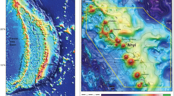
About 12.5 miles off the coast of Farallon de Pajaros, within the Mariana Trench Marine National Monument, lies the Ahyi Seamount, an active underwater volcano. This site remained unexplored until June 22nd, 2016, when the NOAA Ship Okeanos Explorer launched its remotely operated vehicles (ROVs) to investigate the volcano. NOAA originally mapped the site with multibeam sonar in 2003 and 2004. The site was then remapped in December 2014, following an eruption in the Spring of that year. Detected via underwater acoustics by NOAA divers on Farallon de Pajaros, and sensed by land-based seismometers, the eruption lasted three weeks. The result: two new craters at the volcano’s summit and a landslide on the south flank. The ROVs will explore the new craters at 250-500 meters, sampling the new lava and assessing the eruption’s impact on the volcano’s ecosystem.
The dive site lies just below the euphotic zone of the ocean,the region where photosynthesis can occur. Due to hydrothermal activity associated with the volcano, scientists are hoping to find chemosynthetic communities during the dive. Chemosynthesis is similar to photosynthesis except that microbes generate their energy via chemical reactions (as opposed to sunlight). Compounds such as sulfide and methane can be used as energy sources. These compounds may be emitted by volcanoes in the Mariana region, supporting a unique ecosystem. While no chemosynthetic organisms were found on this dive, exploration may reveal chemosynthetic communities in similar sites.
Check out this video to learn more about NOAA’s previous work mapping the seamount!
VIDEO: Ahyi Seamount. Video courtesy of Submarine Ring of Fire 2014 – Ironman, NSF/NOAA. Video produced by Saskia Madlener. Music by Charlie Brooks.
FEATURED IMAGE: Bathymetric maps showing the islands and seamounts that make up the Mariana volcanic island arc (left) and the area of Ahyi seamount in the northern part of the arc (right). Susan Merle of NOAA’s Earth-Ocean Interaction Program created these maps.
Leave a Reply
You must be logged in to post a comment.